Lord Stanley

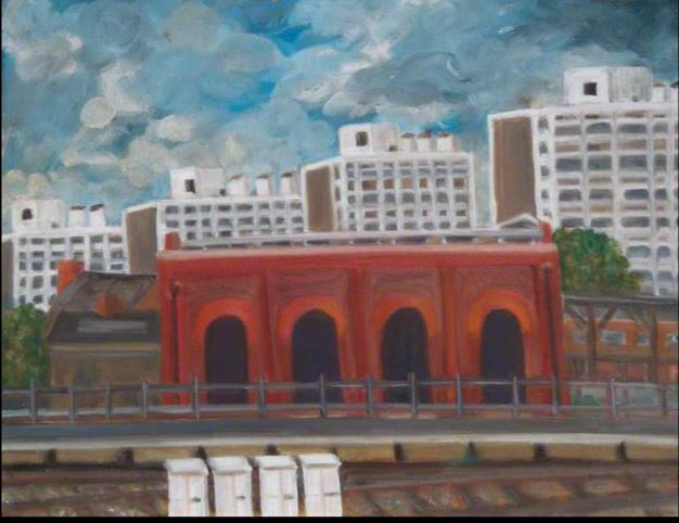
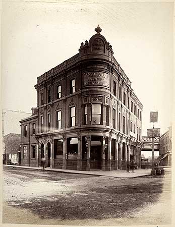
When developers started building the mass housing in Loughbourough Junction they often included Public Houses in their plans and one such was the Lord Stanley at 31 Hinton Road.

Extract from OS Map 1894-96

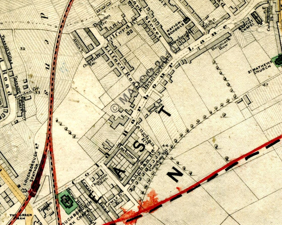
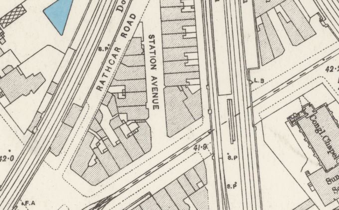
Extract from the OS map 1894-96

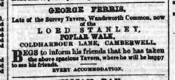
It was taken on by George Ferris in 1869 who advertised this in a number of advertisements in the South London Press, the following from the 15 May 1869 issue.

South London Press 15 May 1869

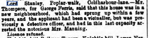
There was, though a hiccup in getting his license for the Lord Stanley as he was refused as this report in the Morning Advertiser 01 April 1869.

Morning Advertiser 01 April 1869 Lord Stanley

You can find out more about the Mannings Murder on this link

http://www.capitalpunishmentuk.org/mannings.html

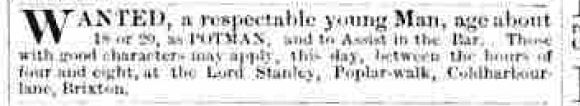
On 29 September 1870 an advertisement for a Potman was placed in the Morning Advertiser .

Morning Advertiser 29 September 1870

The excellent website http://www.pubshistory.com lists a change of Landlord in 1878 as Joseph Harbour became the licensee according to the Surrey Directory and again in 1896 this time from the Post Office Directory. Succeeded by Mrs I Harbour in 1904.  Followed then by Norman Geo. Nursey in 1911, Arthur Valentine Col in 1919, Joseph High Elliott in 1938 and Chas E Hills and Chas E Keating in 1944.

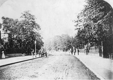
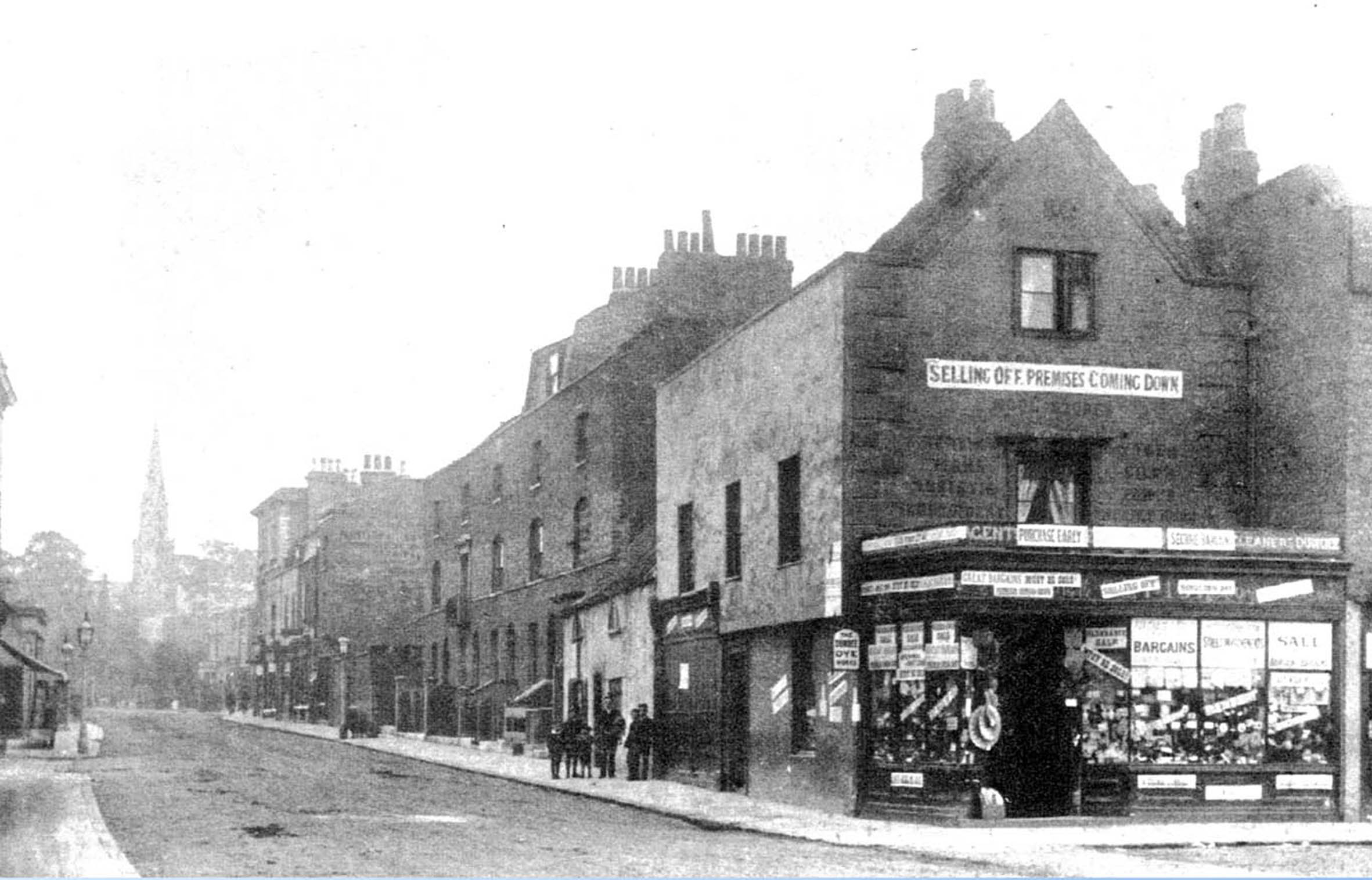
Added: January 2016: Whilst browsing once again through the Lambeth Landmark website, featuring a part of the Lambeth Local history collection held at Minet Library on Knatchbull Road I came across this photograph. It features the top half of the Lord Stanley behind the wagon, taken from the north looking south down Hinton Road with Wanless Road branching off left. It is dated circa 1905 and came from an album of Bovril bill posting sites.

Lord Stanley, Hinton Rd c1905 Lambeth Landmark

http://landmark.lambeth.gov.uk/

In early 2012, I had come across a early photo of a charabanc outing from the Lord Stanley on 28th June, 1925 on a Flikr account Eric06. By the time I went back it had disappeared but after I contacted him, he very kindly e-mailed it to me. Thanks Eric.

Lord Stanley outing 1925

This would be during the time of Arthur Valentine Col. I have absolutely no way of knowing but the gentleman standing on the far left with the cigarette just looks like a pub landlord.

From the very fine website/forum Urban 75 lost pubs section @ the following link

http://www.urban75.org/brixton/bars/lord-stanley-hinton-road-se24.html

A contributor Gill recalls the pub during the war being run by Harry and Daisy Buck, helped by various members of the Buck family. She says the pub suffered bomb damage during the war but continued in operation.

In 1940, as part of a Charrington Brewery survey the following photo was taken.

Lord Stanley, Loughborough Junction,1940 31 Hinton Road, National Brewery Heritage Trust

It now is part of the collection of the

http://nationalbreweryheritagetrust.co.uk/

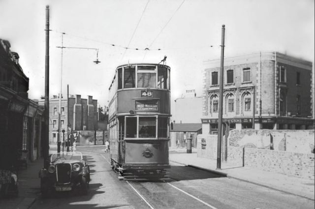
The following photo of Tram 48 taken in January 1952 is part of the B. Maguire collection found on Chris Stanley Flickr.

https://www.flickr.com/photos/rw3-497alh/

tram-route-48-in-january-1952-from-the-b-maguire-collection-on-chris-stanley-flickr

In the late 1970’s and early 1980’s on a number of occasions I had a drink or two in this pub with my friend Jeremy. It was very pleasant but quiet, I think the landlords name was Harry though not 100% sure. And I remember a bird cage.

What I can’t remember is whether the housing next to the Lord Stanley on Hinton Road back to Wanless Road was there or if it was a bomb site.

The pub closed around 1999 and was replaced as so many are these days by a new housing development called Lord Stanley Court.

Lord Stanley Court ,view showing the corner of Hinton Road and Wingmore Road

Posted in Loughborough Junction, Pubs | Tagged , , , | 4 Comments

Coldharbour Lane in the 1860’s

In a contribution taken from The South London Press series entitled South London Sketches published in 1869, there is this article :  Down Coldharbour Lane.

As a reference I include this extract from Edward Stanford’s Library Map of London and it’s Suburbs, 1862. It is clear that even in a few years great changes had taken place along Coldharbour Lane.

.Extract from Stanford's Library Map of London, 1862

Available from Mapco : http://london1864.com/stanford66.htm

An alternative map from 1865 by Edward Weller, Camberwell & Peckham, Suburbs of London.

Camberwell and Peckham, Suburbs of London,sheet 5, Edward Weller for the Weekly Dispatch, British Library 1865

SLP 3 Oct 1869 one

Denmark Place Baptist Church a

The Denmark Place Baptist Church , picture copied from The Church Under the Hill, By W.Y.Fullerton

Next the Sun and Doves, a photo from the 1880’s by H &  R Stiles found on the Historic England website.

al2384_006_01.jpg

SLP 3 Oct 1869 two

20151108_103340

20151108_103504

Photos: taken November 2015

Even then , citizens were petitioning to stop Post Office closures. The Plough is , of course, now known as the Amaryllis Bar.

SLP 3 Oct 1869 three

Denmark Lodge was located on the north side of Coldharbour Lane , the 1st large house after the 4/5 shops mentioned above to the west of The Plough. On the map above , it’s just above the second r in Coldharbour.

https://en.wikipedia.org/wiki/Abernethy_biscuit

SLP 3 Oct 1869 four

Chichester Terrace

Photo: Chichester Terrace, Nick Stevens, April 2015

SLP 3 Oct 1869 five

Taken from the Royal Academy Catalogue from 1846

Exhibitor at the Royal Academy, 1846

SLP 3 Oct 1869 six

South London Press Oct 14 1885

A Court decision refusing an application by Silas Gedding, for continued use of his Cow sheds on Coldharbour Lane.

South London Press, 14 October 1865

In the above paragraph , mention is made of the Five Sisters .

…where stood five trees called the “Sisters”. Check out the map above and you will see the sisters indicated.

slp-3-oct-1869-seven

Mention is made of Strawberry Hall in a couple of Histories I have read and had previously found confusing. It stood on the land later occupied by the Loughborough Park Congregational Church.

SLP 3 Oct 1869 eight

al2387_034_01.jpg

The Green Man photographed by H & R Stiles in the 1880’s found on the Historic England website.

www.historicengland.org.uk

Hannah Brown was murdered by James Greenacre in Paddington and parts of her body were found in different areas of London . Two labourers working in an Osier bed fifty yards off Coldharbour Lane found legs and thighs tied up in coarse sacking.

Tenpenny’s Farm was just off Coldharbour Lane probably around Loughborough Junction probably around Shakespeare Road / Loughborough Park streets.

tenpennys-farm-00230-640 Ideal-Homes circa 1800, Urban c 1725

Tenpenny’s Farm, Coldharbour Lane, circa 1750. A photograph of an earlier drawing. Listed as circa 1800 on http://www.ideal-homes.org.uk/lambeth/lambeth-assets/galleries/brixton/tenpennys-farm

The Fox next to Loughborough Road station is a new one on me. Having looked again at the buildings around LJ Train station, is this building a candidate.

This extract from the Ordinance Survey 1893-96 shows it as quite a big space including what is now a seperate launderette.

Extract from ordinance survey 193-96

20151104_154030

Photo: November 2015

It looks to have been completely remodeled  & divided at ground floor level at some point and the corner site was latterly a dental surgery at one time run by Dr Suh, who was sentenced to prison for defrauding the NHS.

Or most likely completely rebuilt.

SLP 3 Oct 1869 nine

Posted in Loughborough Junction, Old Photos, Pubs, Streets & Roads | Tagged , , , , | Leave a comment

Disappeared Loughborough Junction – a totter on Flaxman Road

totter-1

Photo: Nick Stevens around 1980-81

Looks to be taken from outside the Wickwood Tavern with the entrance to Gordon Grove on the right.

Posted in Loughborough Junction, Old Photos, Streets & Roads | Tagged , , | Leave a comment

Windy Days at Loughborough Junction by Wendy Sullivan

Capture

Windy Days at Loughborough Junction by Wendy Sullivan. Painted 1990.

http://www.wendysullivanartist.com/

Posted in Loughborough Junction, Paintings & Drawings | Tagged , , | Leave a comment

The Changing Face of the Triangle: corner of Coldharbour Lane and Denmark Hill or where Nando’s is now

1833

7

A drawing taken from The Church Under the Hill, WY Fullerton, published 1924

1890

The Triangle 1890, including Golden Fleece Wool Stores, closing down sale for demolition to make way for Metropole Theatre

Buildings demolished to make way for the new Metropole Theatre.

1894

Metropole Theatre under construction 1894

The Metropole Theatre under construction.

Undated postcard but early 1900’s

Denmark Hill and Theatre Metropole Albert Flint Undated

Postcard circa 1908

Denmark Hill (111) pu 1908

The Metropole was succeeded by the Camberwell Empire

Coldharbour Lane With Metropole and Tram Route 74 1920 Silent Movie

The Camberwell Empire Theatre, 1907 renamed in 1906 oreviously The Metropole Theatre

In 1939 The Camberwell Empire was demolished and replaced by the Camberwell Odeon but not before it spent some time as the New Empire Cinema.

The New Empire Cinema had it’s entrance in the traditional corner position.

The Odeon was built by Mather & Roberts and and seated 2,470- 1,484 in the stalls and 986 in the circle. It opened on 20th March 1939 with Fred McMurray in “Men With Wings”.

The Odeon had dual matching entrances one on Denmark Hill and one on Coldharbour Lane. Each entrance had a tower above it with Odeon signage.

It suffered some minor bomb damage during 1944 and this was quickly patched up.

1954

4347631428_a9bfbdfc08_b Camberwell Odeon, 1954 camberwellgazette flickr

1960

Capture

Odeon Camberwell, 90 Denmark Hill

The Dad’s Army film shown in the photo below had it’s South London release on April 11, 1971 following it’s premiere at the Columbia, Shaftsbury Avenue, March 15 1971.

camberwell Odeon 1971 date of release of Dads Army

In it’s last years the entrance on Coldharbour Lane (see below photo) was closed off as was the Stalls. The Odeon was closed on 5th July 1975 with it’s final film being The Night Porter starring Dirk Bogarde.

And on 24 January 1981 Dickie Dirts -a discount jeans emporium moved in.

Odeon Camberwell Dickie Dirts logo on Tower

Dickie Dirts Badge

Camberwell Odeon with Dickie Dirts sign on Tower Ian Grundy www.flickr.comphotosstagedoor365965077

Photograph taken by Ian Grundy in 1987.

Dickie Dirts only lasted a few years and for a long time probably around 10 years the building was abandoned and allowed to decay, often occupied by squatters. In 1993 the old cinema building was demolished and the Foyer was built.

Two photos by Nick Stevens, April 2015

Junction of Coldharbour Lane and Denmark Hill , April 2015 Nick Stevens

Corner Denmark Hill and Coldharbour Lane, April 2015 Nick Stevens

References:

http://www.cinematreasures.org

https://www.flickr.com/photos/stagedoor/   The Flickr site of Ian Grundy.

Posted in Denmark Hill, Loughborough Junction, Streets & Roads | Tagged , , , | Leave a comment

Loughborough Junction by Stephen G Bird

A painting by Stephen G Bird titled Loughborough Junction and dated 2010.

Loughborough Junction by Stephen G Bird httpstephenguyonbird.blogspot.co.uk

https://www.sgbirdart.uk/work


Posted in Paintings & Drawings | Tagged , , | Leave a comment

What and where was the Coldharbour?

A Coldharbour or Cold Harbour or Coal Harbour derives from Saxon times and describes a cold abode, a cold retreat. They could be found all over England. Olive Walker estimates some 200 Cold Harbours scattered about the country.

Often said to be a place where wayfarers perhaps particularly drovers could safely rest their stock overnight on a journey to market or back.

One assumes that over time a Cold Harbour that was well used and popular, would have a service industry develop around it.

The Cold Harbour is not often mentioned in local histories of Camberwell or Brixton.

However, Olive M Walker suggests her book, A Tour of Camberwell that the Cold Harbour was located within the boundaries of the Manor of Coldharbour which abutted the Lane then known as Camberwell Lane as shown in the following map by John Roque.

mAP

Extract from John Roque Map of 1766

Here is an extract from Location of Manors and Early Estates found in A History of Brixton by Alan Piper, published by the Brixton Society. it has been super-imposed over a modern street plan.Extract from Location of Manors and Early Estates Alan Piper Brixton Society Collection

She suggests that it was in the northern corner of the group of buildings shown in the Roque map. The manor comprised ” a mansion house, two barns, a stable, garden, orchard and meadow and pasture lands”. She also mentions the existance of an old Inn on the north side of Coldharbour Lane opposite Harbour Road. I have not turned up any other references to this Inn, to date.

These buildings as shown in another map

Blog-picture

References

JC Hahn , two articles on the origin of the name Coldharbour, 1 April 1865, found at

http://www.cantab.net/users/michael.behrend/repubs/karslake/pages/hahn.html

A Tour of Camberwell by Olive M Walker, published HH Greaves, 1954

A History of Brixton by Alan Piper, published by The Brixton Society,1996

Posted in Loughborough Junction, Streets & Roads | Tagged , | Leave a comment

A Pictorial Stroll down Coldharbour Lane in the 19th Century

In this post I have put together a number of drawings, paintings and photos that represent scenes of Coldharbour Lane throughout the 19th Century. With some of the earlier dated drawings it is impossible to precisely pinpoint the location. With others you can take an informed guess.

Cold Harbour

This drawing of Cold Harbour, a large late Georgian house built near to the original Coldharbour Farm, east of Loughborough Junction. Dated 8th July 1804 it is an ink drawing by John Claude Nattes and is part of the Lambeth Landmark History Collection held at Minet Road Library.

In the following extract from Kennington to Peckham, circa 1830 from the Southwark Council Map Collection you can see only two potential buildings big enough to be  the large house represented in the drawing. On the north side of Coldharbour Lane approx opposite where Harbour Road is now.

extract from Kennington to Peckham, circa 1830

The next four drawings are of cottages in Coldharbour Lane . The 1st two are dated early 18th Century

Coldharbour Lane cottage (date unknown) H.M Wooler LL

This is by HM Wooler, titled Coldharbour Lane cottage, date Unknown. Part of the Lambeth Landmark local history collection, Minet Library.

lz254 early 19th C Graphite Drawing Coal Harbour Lane, Camberwell

An early 19th C graphite drawing titled Coal Harbour Lane, Camberwell found on the Sulis Fine Art web site and marked as Sold.

untitled John Varley Coldharbour Lane , 1817 pencil and watercolour scanned and enlarged

This pencil and watercolour is by John Varley dated 1817 and was sold at auction at Christie’s in 2007 for £6,000. It’s title is Coldharbour Lane, Brixton.

Coldharbour Lane early 19th C L Johnstone SAC

Called Coldharbour Lane and part of the Southwark Art Collection, it is dated early 18th Century and is by L Johnstone.

Next we have Tenpennies Farm for which we have two versions of both it seems copies of the original drawing. The first is held by Lambeth Landmark and is is called Tenpenny’s Farm in Coldharbour Lane, Brixton.  Described as a photograph of an earlier pencil drawing c. 1750, though the same picture on http://www.ideal-homes.org.uk says c. 1800.

tenpennys-farm-00230-640 Ideal-Homes circa 1800, Urban c 1725

The next is a Painting by Guy Miller c.1925 in the Southwark Art Collection and called Tenpennies Farm, Cold Harbour Lane.

Tenpennies Farm, Cold Harbour Lane c 1925 Guy Miller SAC GA1174

Tenpenny’s Great Osier Farm was probably located off Coldharbour Lane around the Loughborough Junction area … it is described as being “close by to Loughborough House in Olive M Walker’s Tour of Camberwell, published in 1954.

Next, a group of pictures from the 1830’s starting with one we have seen before on this blog: David Cox and Green Man Lane known now as Loughborough Road.

Green-Man-Lane-in-Brixton-David-Cox-Chris-Beetles-Gallery-1

Still to be found at the Chris Bettles Gallery.

Emslie

Cottages in Coldharbour Lane, 1830 by John Phillipp Emslie, part of the Southwark Art Collection. Not a particulary fine image as I had to collect it from a tiny snapshot image.

The Parish Clerks Almshouses on Denmark Road, 1830 from the Lambeth Landmark local history collection, Minet Library.

Parish Clerks Almshouse Dean and Munday 1830 LMA P5252301

And from a print in The Church Under The Hill about the Denmark Place Baptist Church an image of the corner of Denmark Hill and Coldharbour Lane known as the Triangle for many years dated 1837. Credited as by courtesy of Mr PM Johnston. The original Baptist Church was 4th building along from the left.

7

Interesting view of Denmark Hill as a narrow track.

Next from 1861 we have the Chapel for Converted Jews otherwise known as Loughborough Park Congregational Chapel. Situated on the corner of Coldharbour Lane and Herne Hill Road directly opposite the Loughborough Junction train station entrance.

0997 The Chapel for Converted Jews, Cold-Harbour Lane The Building News, April 26 1861x

An early photo from the Southwark local history collection shows a street view of Coldharbour Lane c.1880.

Coldharbour Lane, c1880 Southwark Art Collection

Next, very early photos from the 1880’s . 1st up, a view of the Sun & Doves now known as The Sun of Camberwell, as shown on the Historic England website.

al2384_006_01.jpg

Two views of the Green Man at Loughborough Junction also from the Historic England website.

al2387_034_01.jpg

al2387_033_01.jpg

And five views of the Triangle – the junction of Coldharbour Lane and Denmark Hill, the first two showing the  original buildings before they were demolished to make way for the Metropole Theatre. The first, a view from 1889 and the second from 1890.

Corner Denmark Hill and Coldharbour Lane, 1889 buidlings replaced a few years later by the Metropole Theatre Southwark Library

The Triangle 1890, including Golden Fleece Wool Stores, closing down sale for demolition to make way for Metropole Theatre

And a close-up of The Old Baptist Church of Dr Carr’s, photo from Southwark local history collection. Undated.

The Old Baptist Church of Dr Carrs

And then two views of the Metropole Theatre, first under construction in 1894. A photo image that was for sale on ebay and then from a postcard view of the completed theatre.

Metropole Theatre under construction 1894

Metropole

References

Lambeth Landmark, local history at Minet Library

Historic England  www.historicengland.org.uk

Southwark Council Art & Map local history collection

Tour of Camberwell by Olive M Walker, 1954 HH Greaves.

The Church Under The Hill by WY Fullerton, published by The Carey Press,1937

Sulis Fine Art  http://www.sulisfineart.com/

Chris Beetles Gallery http://www.chrisbeetles.com/

Christies  http://www.christies.com/

Posted in Coldharbour Lane, Old Photos, Paintings & Drawings, Pubs, Streets & Roads | Tagged , , | 1 Comment

Paramount Metals sign, Coldharbour Lane

SONY DSC

SONY DSC

Photo taken by Nick Stevens, April 2015

Posted in Streets & Roads | Tagged , , | Leave a comment

Goodies, 74 Denmark Hill, Camberwell by Jonna Pedersen

Goodies, 74 Denmark Hill, Camberwell, London Jonna Pedersen

http://www.jonnapedersen.dk/

Acrylic on canvas 134×170 cm

Posted in Denmark Hill, Paintings & Drawings | Tagged , , , | Leave a comment